

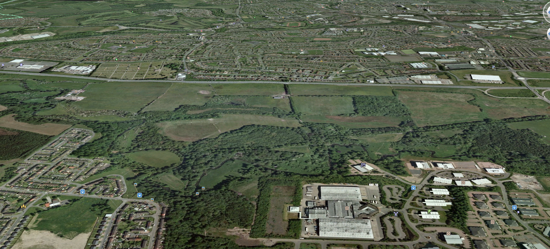
Aerial view from the south
Douglas Support in 2001
The following description, dating from 2001, does not take into account the impact of the construction of the M8 motorway, which cuts a swathe through the northern section of the Douglas Support Estate.
The origins of the Douglas Support Estate can be traced back to the 17th century. The existence of a well-established and extensive area of policy woodland and parkland seems to be confirmed in a plan of 1752. By 1859 the OS plan shows the designed landscape and the later plan of 1898 shows a formal landscape setting for the mansion house (Rosehall House), gardens which incorporate riverside walks and circuit paths, policy woodland and parkland incorporating scenic drives from lodge houses. The house was demolished in 1939 and the subsequent neglect and abuse (exacerbated more recently by vandalism and fly tipping) has resulted in the degradation of the quality and integrity of the designed landscape.
During the latter half of the 19th century and first half of the 20th century, there were 2 collieries within the northern half of the site, including a series of mineral railways.
Planning permission was granted in 20/11/92 for the "Infilling, Grading and Restoration of Land and Formation of Temporary Haul Roads" within the site (ref. No. M/91/254). This allowed for the removal of the Alderston Bing (to the south of the site) which then facilitated the development of the Strathclyde Business Park. Two parts of the site (extending to around 14 ha) were raised and subsequently shaped and landscaped.
In the early 1990's, Monklands District Council and the Trustees of the estate created a joint venture company with a view to promoting the site for business and industry. This agreement lapsed following Local Government re-organisation and the applicant (Park Lane Palisade) was appointed by the Trustees to continue with the promotion in 1997.
In the early 1990's, the Scottish Office had plans to complete the motorway connection between Newhouse and Baillieston. This was designed to allow for the retention of the existing A8 as a local distributor road which was to be supplemented by a new "off-line" 6-lane motorway. Within the application site, the new motorway was to have been sited within the northern half of the site (roughly from a line from the north west corner towards half way down the eastern boundary). These plans were at an advanced stage (tenders approved and land acquired through Compulsory Purchase Orders) when they were shelved in 1997. Since then, the Scottish Executive has confirmed its commitment to upgrade the A8 to motorway standards before 2010 (Central Scotland Transport Studies: January 2003) although a decision has yet to be taken on whether this will be built on or off line. The Douglas SupportThe Douglas Support Estate extends to 120 hectares (300 acres) and is located between Bellshill and Coatbridge alongside the AS, west of the A725 at Shawhead. The boundaries and immediate surroundings are described as follows:
North
The estate is bounded mostly by the A8 with small areas protruding northwards at the Old Lodge Cottage and Shawhead junction. Adjoining the A8 at this location (west to east) is part of Old Monklands Cemetery, a recent housing development by Wimpy, Old Lodge Cottage, a vacant area of ground which is currently the basis of a reserved matters application by Strathclyde Homes for 33 houses industrial units at Rosehall Industrial Estate and finally Shawhead junction (including the recently completed road improvements comprising a new roundabout) with housing and industrial units within Rosehall to the north and east.
East
For the most part, the A725 Bellshill Bypass marks this boundary although part of the boundary extends slightly to the east of that road towards part of the North Calder Water with residential areas off North Road Bellshill to the south-east.
South
The wooded valley of the North Calder Water bounds the entire southern edge of the site. The north-most edge of Strathclyde Business Park and Righead Industrial Estate share a boundary with the application site at this point. The Business Park is now well established although there are further development areas at the north-east corner of the Park. At the south-west corner of the site lies a residential area which forms part of Viewpark.
West
This comprises a field boundary and adjoins agricultural land of Bankhead Farm further west.
The topography of the estate is one of gentle undulation, with the steep valley sides of the North Calder Water along the southern boundary. Ground levels vary from 87m AOD at the north-east corner to 57m AOD at the south-west. In general, the estate can be separated into 3 distinct areas:
The top half of the site is characterised by gently undulating agricultural grazing land interspersed by some blocks of woodland and tree belts. This is traversed west/east by electricity pylons and below ground by a high-pressure gas main. At the north west corner of the estate is the farmhouse and buildings of Shawhead Farm. A burn runs east to west towards the North Calder water through the western half of this area. There are some areas of standing water including the marshy area known as the Crow Flat pond at the north-west corner near the farm.
Further south is the remains of the planned landscape which formed part of the policies of the now demolished Rosehall House. This area comprises some areas of grazing land enclosed by mature woodlands, tree lined paths and limited remains of the house and its estate buildings. The former access to the house is still recognisable as a tree lined track which runs west/east across the south-east of the site toward s the A725.
Finally, alongside the southern boundary is the steep wooded valley of the North Calder Water.
There are currently 3 main points of entry to the site. Firstly, there is a vehicular access directly off the A8 which connects with Shawhead Farm. Secondly, pedestrian access can be taken from what was the original main access to the estate off the A725. Lastly, a footpath connection at the south-west corner of the site connects the site with Strathclyde Business Park (to the rear of the Grants bottling plant,) Viewpark (off Laburnum Road) and Righead Industrial Estate.
The northern half of the site can be seen quite clearly from the A8 corridor and the A725 at Shawhead, whilst clear views of the southern half of the site can be had from Viewpark, Strathclyde Business Park and the adjoining stretch of A725.
The estate is farmed from Shawhead Farm (tenanted) and comprises mostly grazing with some arable production. The majority of this land (85%) is quantified as being Grade 3.2 (good quality) with the remainder being of a lesser quality.
There is much evidence of neglect and vandalism throughout the site including burnt out cars (estimated to be at least 30 on recent inspection) fire damaged trees, fly tipping (particularly at the access from the A725) and evidence of anti-social behaviour including large numbers of empty beer cans.bsp;
A desk-based study and reconnaissance field survey were undertaken in February and March 2001 towards the preparation of a cultural heritage chapter for an Environmental Statement for a proposed business park within the Douglas Support Estate, near Coatbridge.
Eight sites were noted. Two known sites were a prehistoric burial site (NS76SW 1) and a battle-axe findspot which may relate to the same site (NS76SW 20). No field remains of the burial site were observed, and its former location has been partly disturbed by a recent pipeline development.
Two former coal mines (Rosehall Colliery Pits 3 and 12: NS 727 626 and 720 627) have largely been landscaped and reclaimed, and fragments of the former mineral railway network survive in the surrounding landscape. Two annular enclosures (NS 726 624) and a curvilinear parchmark (NS 722 629) were detected on vertical aerial photographs, but no surface traces of these sites were identified through field survey.
Part of the former Douglas Support Estate grounds lie within the study area. Field survey confirmed that most of the former estate buildings, including the country house at NS 722 621, have been demolished, although the ruins of the estate offices (NS 723 623) and a mausoleum (NS 720 623) survive, and the 19th-century terraced gardens overlooking the North Calder Water remain as substantial earthworks. The former garden features of the estate have largely been removed, although surrounding parkland features survive in good, if neglected, condition. bsp;